Brother Mark and I woke up to temps in the low 40s Saturday. Even HE wasn’t ready to hit the road until the thermometer thawed out. He had to be in St. Louis for a concert in the evening, so we decided to do a short historical ride, starting in South Cape Girardeau.
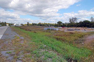 When I worked at The Southeast Missourian, South Cape was the euphemism we used for what everyone else in town called Smelterville (or, going back even more, Leadville). It was in the area of town that frequently flooded and was inhabited almost exclusively by poor black families.
While I was still in high school, I launched myself into a daring anthropological expedition to venture into Smelterville with my camera. If I wasn’t on the road, without access to them, I’d stick in some of those old pix. I think they stand up pretty well.
None of the dire things I had been warned about happened. Instead, I found myself and my camera being invited into homes and I discovered something that served me well throughout my whole newspaper career: most folks are pretty darned nice if you treat them with respect and dignity.
 You can’t fight the river
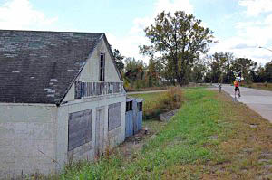
Old Man River took its toll over the years. More frequent and worse floods damaged many of the homes beyond repair; the roadbed passing through the community was raised and white flight to the suburbs opened up housing nearby that didn’t go under water. In 1996, after two “100-Year” floods in 1993 and 1995, many homes qualified for a government buyout program.
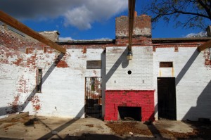
I didn’t see a single home in the area on this trip. Only the roof of this old furniture company sticks up above the roadbed.
I miss the Blue Hole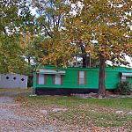
A green house trailer sits where the Blue Hole Restaurant used to serve up the best BBQ sandwiches in the area. I can remember going with my dad in his truck and wolfing down Brown Hots served on authentic Coca Cola metal trays.
The place was named after the limestone quarry next to it. When it filled with water, it looked like a Blue Hole.
Well, it sounded like a good idea
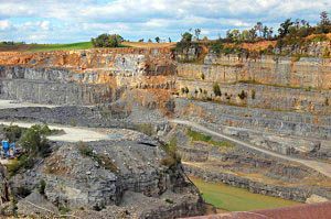 The quarry provided limestone for the Cape Cement Plant (since sold and renamed numerous times), once one of the largest employers in the area. Back before anyone ever thought about pollution control, the cement plant would billow out huge plumes of white dust that would cover everything for miles around.
The quarry started as a deep pit, and then was mined horizontally, leaving huge stone pillars to support the roofs. Back in the days of the Red Menace, I covered a city council meeting where it was discussed that those deep caverns would make a great fallout shelter.
How long can you hold your breath?
“Remember that they used to call that the Blue Hole because it fills with water if it’s not constantly being pumped out? How long do you think we could hide in those holes if the quarry filled up?” I asked innocently.
I never heard any mention of quarry-based fallout shelters again.
About 30 or 35 years ago, the pillars were blasted out and it changed to a deep pit quarry again. I managed to talk my way into the caverns to document them just before they were blown.
Everyone in Cape has heard of Fort D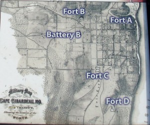
Nobody ever goes to see it, but they’ve heard about it. Larry J. Summary posted this image of Cape’s forts. Fort D is the only one that has survived.
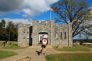
The site is nicely landscaped and the fort itself looks good until you notice that it has no roof.
Here’s an account good enough to borrow
Scott House, a retired teacher, and a member of the city’s Civil War Round Table, is leading an effort to interpret the fort’s history.
 The forts were ordered built by Gen. John Fremont, the Western Department’s Union commander in St. Louis. Fremont dispatched a contingent of engineers to the town to lay out the forts. Assisting in the project was an officer, John Wesley Powell, who after the war would earn a name for himself exploring the Colorado River and the Grand Canyon.
Built in the summer of 1861, the four forts formed a crescent along the outskirts of town. House said a copy of an 1865 map drawn by Army engineers, now in the Library of Congress, provided a period look at the forts‚ dimensions and their proximity to the town.
Fort D had a palisade on one side with cannon emplacements and rifle pits. It also included “Quaker cannons” — logs carved to look like cannons. House said the name came from the Quakers, “a religious group that generally declined to fight during the Civil War.”
Quaker cannons relieved boredom
House believes the faux cannons were probably the result of boredom and built for amusement.
House, who also works part time for the National Park Service, said life for the men who served at Fort D was never too exciting.
“As far as we know, they never fired their guns in anger,” he said.
Soldiers at Fort D, trying to occupy the long hours, ended up carving bowling pins and used one of their 32-pound solid-shot cannon balls as a bowling ball. According to House, one of the soldiers, Benjamin Radford, noted the bowling ball “gave strength to our arms.”
“You know you’re in the backwaters of the Civil War when you are using your cannon balls for bowling balls,” House said.
Like George Washington’s axe
There’s an old joke about an antique shop that advertised itwas selling George Washington’s axe, maybe even the one that he used to cut down the famous cherry tree.
“That axe looks like it’s in awfully good condition for being that old,” a prospective customer remarked.
“You have to understand that it’s had three new handles and two new heads since George used it,” the shop owner countered.
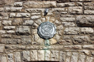
That’s the way Fort D is. I commented to Mark that the foundation was concrete, not the stone that I would have expected from Civil War construction. It turns out that the American Legion saved the site from development by buying it in 1936. The building we were looking at was a WPA construction project in 1937.
It’s a beautiful site and the interpretive plaques do a good job, but it sure feels like Washington’s axe when you hear the rest of the story.

Blue Hole better than Wibbs?
Blasphemy!
—Matt
Wib’s and the Blue Hole were pretty similar. I was introduced to Blue Hole BBQs first, so I have a soft spot for the whole experience.
The newly-remodeled Wib’s has windows and is brighter than the old version. Blue Hole had the quarry and rocks you could climb on.
When we’d go fishing, we’d visit The Worm Man, who had a small place at the top of the hill overlooking the quarry. The road was right on the edge of a 300+ foot dropoff.
I know now that the road was setting on solid limestone and was unlikely to slide into the pit, but in those days I wiggled more than the worms on the way up and down.
I decided to raise Fort D’s grade from a D- to C-.
It may not be the original landscaping and original fort and it may not have a roof, but it’s still a neat site.
Unless I was a hard-core Civil War buff, I don’t know if I’d drive hundreds of miles to see it, but it’s nicely documented and well-maintained.
Kids raised on video games will be disappointed unless you use a little imagination and describe how the cannons would go BOOM! at the fort and cause a 32-pound cannon ball to splash in the Mississippi River nearly a mile away.
I loved this quote, “You know you’re in the backwaters of the Civil War when you are using your cannon balls for bowling balls,”
I don’t know how much time my Dad and I spent at the old Blue Hole Bar-B-Q, but I think it was my favorite joint to eat. One time the owner, Ralph Brenneke ( I think that’s correct ) asked me if I wanted “minced”, a type of ground pork with seasoning. I thought he said “mints” (candy), and I was all over that!! Imagine mt confusion when he served me theis sandwich with mush inside! BLEAH! Everyone had a good laugh, but I wasn’t eating that! The Blue Hole didn’t seem the same after its move to N. Kingshighway.
I used to deliver Coca-Cola products to folks in Smelterville when I worked for my Gandfather in the mid ’60’s. I agree, Ken, that everyone was very congenial…sometimes more so than other parts of town. I do remember wondering at the living conditions there.
John,
I agree on the minced BBQ. I was never fond of it.
I’ve been pulling aside Smelterville pix and some shots of what the Blue Hole looks like today for a future posting at
http://www.capecentralhigh.com/
I have a whole selection of color photos taken down in the quarry before they blasted the caverns that I’m going to edit and post before long.
There’s not enough hours in the day to get around to all of this stuff.
I have to point out that the stone structure at Fort D is not the actual Fort. It is a museum that was built, the actual fort itself was an earthen fort , the little hills surrounding the outskirts of the area were the walls, much like Fort Davidson at Pilot Knob. Also the Quaker Cannon was used as a form of Psychological Warfare, from the river you can’t tell if a Quaker Cannon is real one or not, making the Fort look more armed than it actually was.
Richard,
That’s why I gave it a D-, later raised to a C- .
Still, it’s an interesting place to visit. The plaques are nicely done.
Interesting information on old Fort D- As a 12 year old I attended scout meetings in the building. As I recall Fort C was a stone castle like structure in the rail yard on Independence ST., across from the police and fire station and west of Lorimer School. At least it was still standing when I was a kid. I remember the site well because I was afraid of steam engines and once my father stopped a switch engine and the engineer gave us a short ride down the track. It cured my fear instantly.
The General John Freemont was also the first Republican presidential candidate in 1856. Lincoln campaigned on his behalf and was elected the first Republican president in 1860. At that point the sole purpose of the party was to stop the expansion of slavery into new territory and Lincoln was opposed to the Democratic Douglas concept of popular sovereignty, or states rights…In those days the south was solid democrat until the parties switched principles in the mid 20th century. But that is history. PS—I have worked on the Lincoln Heritage Project and portrayed Lincoln in Shelby County, Illinois for several years. We succeeded in commissioning a set of statues of Lincoln and local lawyer Anthony Thornton, whom he debated in 1856 [while he was campaigning for Freemont] and two years before his more famous debates with Douglas on the same issue.
Sorry, David, but Fort C was not the building you refer to. Fort C was an earthwork fort (as were all the Cape Girardeau forts) at the location where the old St. Francis Hospital was later built at the corner of Pacific and Good Hope, and was destroyed by the construction of the hospital. Today there are condos there. The building you remember west of Lorimier School was the old Houck Train Station, which was built in a similar style to the blockhouse at Fort D, but later than the Civil War. Earthwork forts were the most commonly built forts in our region during the Civil War. If you think about it, the limestone buildings at Fort D and the old Houck Station would have been utterly demolished by one cannon ball hit. Earthwork walls can absorb a lot of hits and still be effective. Not as picturesque, but certainly more functional.